|
|
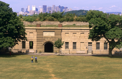
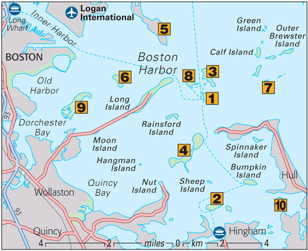
Georges Island
As
the terminal for the harbor islands ferry and water shuttles to other
islands, Georges Island is the gateway to the Boston Harbor Islands
National Park Area. This undeveloped archipelago of 30 islands consists
of 1,200 acres (485 ha) spread over 50 sq miles (80 sq km) and is made
up primarily of drumlins, or piles of glacial debris. The prime
attraction on Georges Island is the massive Fort Warren, a prison for
Confederate soldiers during the Civil War.

Fort Warren, Georges Island
Grape & Bumpkin Islands
Both
these islands are naturalist’s delights – Bumpkin for its wildflowers,
raspberries, and bayberries, Grape for its wild roses and bird life. On
Bumpkin Island, hiking trails pass the ruins of a farmhouse and
19th-century children’s hospital, which also housed German prisoners
rescued from Boston Harbor in World War I.Peddocks Island
Peddocks
is one of Boston Harbor’s largest and most diverse islands. Hiking
trails circle a pond, salt marsh, and coastal forest and pass numerous
buildings of interest including Fort Andrews, active in harbor defense
from 1904 through to World War II. The island is known for its black
crowned night herons and for the beach plums and wild roses which bloom
profusely in the dunes.

Peddocks Island
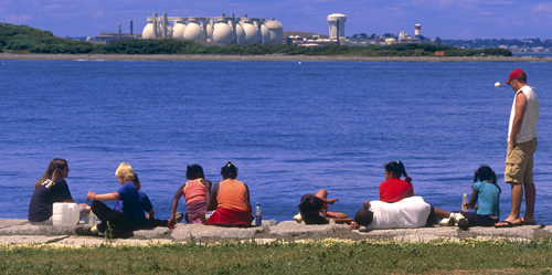
Deer Island
Accessed
by a causeway attaching the island to the mainland, 60 acres (24 ha) of
the island were recently opened for recreation and walking – with
dramatic views of the Boston skyline. Deer Island is also known for its
impressive, state-of-the-art $3.8 billion sewage treatment plant.
Distinguished by 12 gigantic egg-shaped digesters, it was key to
cleaning up Boston Harbor.

View of Deer Island from Georges Island
Spectacle Island
Vastly enlarged by fill from the Big Dig,
Spectacle Island has some of the highest peaks of the harbor islands
and the best Boston skyline view. The construction of a new café and
visitor center has made it one of the most popular of the harbor
islands. Visitors enjoy 5 miles (8 km) of trails and swimming beaches
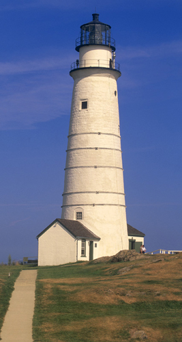
with lifeguards.Boston
Light, the first US lighthouse, was constructed here in 1716 and it
remains the last staffed offshore lighthouse in the country. Limited
tours visit the small museum and lead visitors up the 76 spiral steps
and two ladders to reach the top.Call for schedule
Reservations essential 617 223 8666
Adm

Boston Light, Little Brewster Island
Gallops Island
Once
the site of a popular summer resort, Gallops also served as quarters
for Civil War soldiers, including the Massachusetts 54th Regiment.
The island has an extensive sandy beach, a picnic area, hiking paths,
and historic ruins of a former quarantine and immigration station. The
Massachusetts Department of Conservation and Recreation has closed the
island indefinitely for a thorough environmental clean up.World’s End
This
244-acre (99 ha) peninsula overlooking Hingham Bay is a geological
sibling of the harbor islands, with its two glacial drumlins, rocky
beaches, ledges, cliffs, and both salt and freshwater marshes. Frederick
Law Olmsted laid out the grounds for a homestead development here in
the late 19th century. The homes were never built, but paths, formal
plantings, and hedgerows remain. World’s End is accessed by road by
driving through Hingham.Operated by Trustees of Reservations: 1 781 740 6665
Adm to non-members